Walking The Riggonhead Defile: September 21st/ 22nd
The First Challenge was to Locate the Defile!
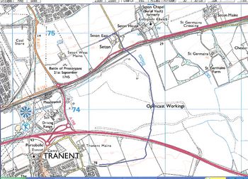
.... but fortunately we have a long serving member of ScotWays, Andrew Ralton, author of Prestoungrange University Press Historical Study # 19: The Roads that led past Prestoungrange and lately ELC/ EU North Sea Walks Supremo, as our adviser. The overlaid modern map below is his "current best educated guess based on looking at old maps [such as Mather's Tranent Runrig System 1770 and William Hunter's Land Plans 1832], and features in Cadell's book which can still be identified today". The challenge arises since the whole area has been open cast mined and the Riggonhead Farm no longer exists. Indeed the area is now known as Blindwells. Perhaps an even greater challenge is the fact that the A1 and the railway both cross the ancient route so absailing may be required this time around.
click on the map to enlarge
Why Walk the Defile on September 21st/ 22nd?
Those who are well read on their tales of the Battle of Prestonpans will know that the Riggonhead Defile was the key to the success of Bonnie Prince Charlie's assault on Sir John Cope's Hanoverian redcoats through the early mists on September 21st 1745.
The Riggonhead Defile was the route through the marsh land at the foot of the Tranent heights across which a Highland charge could scarcely be achieved. By taking the Defile at 4 a.m., Prince Charles Edward repositioned his army in the dead of night to the east of Cope with the opportunity for a direct charge across the waggonway and cornfields forcing the Hanoverian red coats back to the walls of Preston House.
The location of the defile had been brought to the notice of Lord George Murray and the Prince by a young officer, Robert Anderson of Whitburgh, whose father owned the marshland meadow on which he had often hunted.
What Future for The Riggonhead Defile?
The Trustees and many local indwellers are determined that the Riggonhead Defile shall be permanently marked out again, not least since Blindwells has been designated by East Lothian Council as an area for a new eco-friendly housing development. By identifying the Defile on today's landscape and walking as much as possible this coming September 21st/ 22nd, proposals can be created for the future developers to incorporate perhaps a route across the land formally known as The Riggonhead Defile and features or streets named after Robert Andersen, Lord George Murray and Prince Charles Edward.
Andrew Ralton is firm in the opinion that "the Defile must have come out approximately opposite what is now Fisher's Road to Port Seton. And it seems likely that its original path can be accessed from Adniston further to the west or via St Germain's level crossing and the Right of Way past Chesterhall."
The Glenbuckets and Loudons Regiments have already volunteered to do their best to 'Walk The Defile' in September 2007; and local indwellers and Supporters will be invited to join them ... 4 a.m. sounds about right .... with Scotch eggs and a wee dram or Fowler's real ale awaiting them as they cross the waggonway at a run .... donated by The Prestoungrange Gothenburg. The 77th Montgomerie's Highland Regiment from the Czech Republic are also planning to join us.
With guidance from Andrew Ralton and benefits such as these it is expected to become an annual event for the Trustees!
Published Date: May 6th 2007
|